Methods of Inventory: How to read the Map?
The interactive map was modified after Institute of Agronomic Sciences of Rwanda (ISAR), August 1990. Modifications were made according to our observations in the field in 2020.
Information like for traditional medicinal plants (Rwangabo 1993) or Kinyarwanda names (e. g. Monfort 1990) you find in the list of literature.
Mapping of each single Plantation Plot in 2020
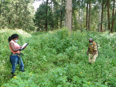
The vegetation of the plots is recorded in three layers: Herb layer (plants up to 1 m height), shrub layer (plants between 1 m and 5 m height) and tree layer (plants above 5 m height) along transects. Within a first inspection, species of a plot's tree layer were identified. Scientific names of all found trees were noted. Here, it was not distinguished between “main species” (as originally planted) and natural regeneration. To be able to capture all plants of the herb layer and shrub layer in the specific plot, the transects had a spacing of 5 m between, so that plants could be identified in a 2.5 m wide corridor on the left hand and a corridor on the right hand side. In case visible species characteristics (e.g. flowers and buds) and therewith a sufficient base for exact identification was lacking, the common abbreviation spec. (species) or ssp. (subspecies) was added as a temporary replacement of the genus name. Literature, such as field guides and identification keys were used afterwards for exact determination.
During the process of categorization into layers it regularly happened that species occurred in more than one layer. Therefore, it needs to be mentioned that not all plants categorized into the herbal layer are exclusively herbal plants, i.e. a young shrub or tree might have fallen into the range of ≤ 1 m. Also, young tree saplings might have occurred in the shrub layer. This was done to be able to analyze specific natural regeneration processes afterwards. As a result, the inventory of plants of the arboretum presented here is a snapshot of the year 2020. Finally, photographs were taken of each of the plots and of specific remarkable plant species.


